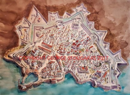
MY HERAKLION
I wanted to develop a map of Heraklion which went beyond the Venetian Maps that have come to represent the Old Town. It was a massive challenge as there are many maps of this old town and the locals are fervent historians. I used material that is not usually used in maps including Ankori's description of the Jewish Quarter of Candia and sketches, photographs and notes made from other maps and my wanderings around the city. This map is an emotional map, encompassing traces of a town that has many hidden and destroyed layers. To that end, I painted in the minarets that were attached to places of worship, apart from the St. Titus one, which by rights should have been the first one. St Titus is a beautiful building, designed by a Greek architect as a Mosque and then appropriated at a later date to serve as a Christian church. That layering and appropriation of the past sums up my motivation to design this map. I would not claim that it is a historically or factually perfect document of the old town, but I would say it attempts to reclaim the character of Greek: Ηράκλειο, Irákleio, Turkish: Kandiye, Italian: Candia. The fact that is often forgotten is that the current capital founded in 824 founded in 824 by the Arabs under Abu Hafs Umar who had been expelled from Al-Andalus by Emir Al-Hakam I and had taken over the island from the Eastern Roman Empire. They built a moat around the city for protection, and named the city ربض الخندق, rabḍ al-ḫandaq ("Castle of the Moat"). It became the capital of the Emirate of Crete (ca. 827–961) (Information from Wikipedia). Minoans,Mycenean Greeks, Doreans, Romans and Byzantines all walked its shores and gazed out to the Aegean. My title is 'These Streets’ because I really feel these streets have seen everything.